New Buckenham - a moated town
New Buckenham was probably laid out as a defended
town sometime in the middle of the 12th century. It
was surrounded by a square moat that was at least
five metres wide and three metres deep. In 1493 this
was referred to as the ‘borough ditch’ and in 1598 as
the ‘greate ditch’. By 1600 the moat was no longer
being maintained and was becoming clogged with
rubbish. In 1632 Charles Gosling, the owner of the
Rookery, was given leave to build his barn across it.
Today only the north-east corner survives to anything
like its original width. The eastern section soon peters
out but garden boundaries mark the inner edge of the
ditch. South of the road the ditch is traceable only
through documentary and archaeological evidence.
The moat continued just to the west of Tanning Lane
where a small excavation [1] in 1993 uncovered its
western edge. By the garden of the Rookery it can be
seen as a faint hollow which was still open water on
1886. The long pond forms the south-east corner of
the moat.
The canalised stream that skirts the southern edge of
the town was formally thought to form part of the
defences. However a map of 1693 shows that the
stream originally formed a more winding course and
another of 1896 labels the present course as a ‘canal’
implying that the straightening was recent. The
southern line of the moat was not discovered until
1993 when work on the foundations of Flint Lodge [2]
revealed a three metre deep ditch. Within the fill
were parts of a wooden structure that was probably
one of the three sluices recorded in 1578.
Further archaeological work by the Norfolk
Archaeological Unit on the site of Woodbury Cottage
[3] revealed a ditch up to nine metres wide with an
internal bank. This confirmed the alignment of the
moat, which appears to have run just north of Marsh
Lane, linking up with a short section of ditch [4] that
has only recently been backfilled.
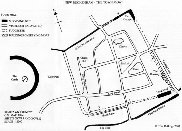
From this point the moat ran north but its line is not
visible until it reaches the parish boundary stone [5]
which probably marks its original inner edge. The
ditch then continues northwards and is visible as a
broad hollow running along the back fences of the
properties forming Chapel Street and Chapel Hill. In
1683 this length was known as the ‘park ditch’
because it divided the deer park which surrounded
the castle from the town. The north-west corner of
the moat links into the castle defences and then turns
east as a well preserved wet ditch that skirts St
Martin’s Gardens and continues along the parish
boundary back to the north-east corner.
There must have been bridges where roads crossed
the moat and these were probably secured by gates at
night. A document of 1597 suggests that there was
some stonework, perhaps a stone gate, on the eastern
(Norwich) side of the town. There were also private
bridges over the moat. Two of the householders
backing onto the ditch are recorded as having their
own bridges in 1567 and 1674 and the late Victorian
iron and brick bridge is a reminder of these.
The ditch’s purpose was probably not just defensive.
It would have also been a symbolic boundary of the
town. The gates may have served as toll collection
points and they would have kept out roughs by night
and stray livestock by day.
Documentary sources in the Norwich Record Office:
NNAS Collection, Frere MSS: PD254/172; MC22; accn
Steele & Co. 23/9/86; MC343/68.
This account was originally published by the New
Buckenham Society.
© Paul Rutledge and Tom Rutledge 2002

© The New Buckenham Society 2015 (rev 2023)
Can you identify people or dates, or add a photo?
or
Cookies are used to link to Google Analytics and Facebook but this site collects no personal information


- Brief history of village
- A moated town
- William Barber's almshouses
- History of village school 1848-1912
- New Buckenham: the history of a market town
- Historic buildings research report (NHBG)
- History of individual properties
- Rogationtide in the 1590s
- Who was Boosey?
- New Buckenham in 1542
- Newspaper articles
- Prince Duleep Singh's photographs
- Vicarage